The depth of the First Basin
Published on 08 February 2018
For many decades, debate swirled about the depth of Launceston's First Basin in the Cataract Gorge Reserve.
A long-lived myth was that the First Basin was so deep it couldn't be measured.
In 2011, surveyors from the City of Launceston's spatial sciences department set out to resolve the question of the First Basin's depth once and for all.
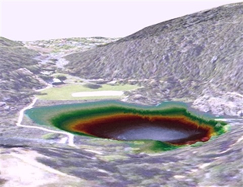
Using a high-accuracy Global Navigation Satellite System, a dual-frequency echo sounder and transducer, and a tablet computer, the team launched a 14-foot aluminium runabout into the First Basin and took a series of soundings in a grid pattern.
The information gathered was then fed into computer modelling software to produce a 3D model of the Gorge, allowing a clear view of the terrain beneath the surface.
The data showed the First Basin, at its deepest point, was about 20 metres.
Its average depth was only 15 metres.
In 2016, the department re-surveyed the First Basin, this time using upgraded versions of its equipment mounted on a kayak.
More than 10000 data points were collected in the 2016 survey, with 20.5m being the maximum depth recorded.
The Council's spatial sciences department has an impressive back-catalogue of work, including liaising with internet giant Google to improve aerial images of Launceston, providing data to include 3D Launceston buildings in Google’s smartphone applications and publishing a growing list of free open spatial data on data.gov.au